
Arctic ice melt, due to global warming, not only intensifies hurricanes, but also steers them in previously uncommon directions, which is why Hurricane Florence hit the Carolinas, says Prof. Jennifer Francis
Story Transcript
GREG WILPERT: It’s The Real News Network, and I’m Greg Wilpert coming to you from Baltimore.
As we are witnessing in the Carolinas with Hurricane Florence, streets have become rivers, rivers become water rapids, and the freeways have turned into freeflowing waterways with rescue boats replacing cars and trucks. The hurricane has been downgraded to a tropical depression and is slowly moving north, dumping heavy rains on the Appalachian Mountains. As of Monday, the storm killed 18 people, trapped many more, and forecasters are saying the worst flooding is yet to come. The storm is expected to move through Ohio Valley, West Virginia, Western Pennsylvania, with even New York and Boston getting extra rain.
In our continuing coverage of Hurricane Florence and its relation to climate change, we’re joined today by Professor Jennifer Francis. She is professor at Rutgers University Institute of Marine and Coastal Sciences. She’s also one of the world’s leading experts on the connection between climate change, Arctic warming, and extreme weather events. Thanks for joining us today on The Real News, Professor Francis.
JENNIFER FRANCIS: You’re welcome.
GREG WILPERT: So you study the effects of melting Arctic sea ice and glaciers, among other things related to climate change. And currently according to some reports there is sea ice off of Greenland, which is sometimes referred to as the cool blob, which has backed up the Gulf Stream, essentially slowing it down like a blocked drain. And some experts have argued that these series of blobs have helped Florence move across the Atlantic into the United States. Can you explain this process to us and how it is all affecting extreme weather right now?
JENNIFER FRANCIS: Right. Well, it’s a little bit complicated, so let’s start with that cool blob of water that’s been located just south of Greenland for the last several years. Recent research suggests that the extra freshwater melting from the Greenland ice sheet, as well as melting sea ice in the Arctic Ocean and extra runoff from rivers that flow into the Arctic Ocean, are sending a lot more fresh water down into the North Atlantic than it used to. And this fresh water is lighter than the heavy, saltier water underneath. And so it sits on top, and it tends to hamper the mixing of the warmer salty water underneath.
And so what we see as the result of this is this blob of cool water sitting there south of Greenland. And as you said, we think this is helping to prevent the warm waters of the Gulf Stream from flowing across the Atlantic quite as as well as they usually do. And so if you look at a map of sea surface temperature differences from normal in the North Atlantic right now, you’ll see that there’s a huge area of much warmer than normal water pretty well all along the East Coast of North America, along with this cool blob south of Greenland.
So one of the things that all this warm water is doing is, of course, we know that hurricanes live off of warm water to get their energy. So having that warm water there is helping to intensify any hurricanes that might come along. But it also increases evaporation, and that provides more moisture for hurricanes to work with which, is undoubtedly making the rains of Florence even heavier than they would have been, say, 50 years ago. And also, all that warm water along the East Coast tends to make the jet stream- and now we’re talking about the atmosphere, not the ocean- but this river of wind high over our heads, when it encounters that warm water there, it tends to make it want to bulge northward. So if you think of, like, a snake traveling around the Northern Hemisphere, the curve in that snake wants to head northward up and over that warm water.
And what that does is it tends to create a very persistent area of high pressure. So as we look at a weather map on the TV, for example, we’ll see a big high part off the East Coast of North America. And that high has been very, very persistent. And it is what created the flow around it. The winds flow clockwise around high pressure areas. And it sent Florence due west into the Carolinas, which is a fairly unusual track for hurricanes to take.
Now, there’s another piece to that story. And that is that with the Arctic warming so fast, it’s helping those bulges northward in the jetstream to become even stronger, because it tends to weaken the winds of the jet stream overall by making the North-South temperature difference smaller than it normally would. So just to back up a little bit, we know the Arctic is warming much, much faster than anywhere else. And so it’s making that North-South temperature difference smaller. And that is one of the main factors that fuels the winds of the jet stream. And so a weaker jet stream is more easily deflected North and South by things like that blob of warm water.
So it’s really this double whammy effect that has led to the atmospheric wind pattern that has both steered Florence in an unusual path. But it’s also resulted in this lack of wind along the Appalachian Mountains. So as Florence came in towards the coast it basically ran into an area with no wind at all, and that’s why it stayed for such a long time in one place. A similar thing happened to Hurricane Harvey last summer. A very, an area of very weak winds was located over Texas. And so as that storm came ashore the same kind of thing happened. It stalled in one place and just kept pumping moisture in from the ocean, from the Gulf of Mexico in Harvey’s case, leading to these incredible rainfalls we’ve been seeing.
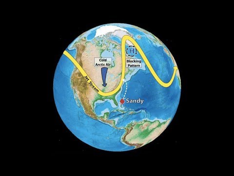
GREG WILPERT: So I believe that you’ve also related the phenomenon to Hurricane Sandy, and relate it to the blocks that have been created. Now, will these blocks become more common and result, in other words, in more extreme weather, such as these hurricanes? And what can be done to mitigate this type of phenomenon?
JENNIFER FRANCIS: Well, there is some evidence published in some very recent papers suggesting that these kinds of blocks in the summertime have increased in frequency over time, especially in the last couple of decades, which is consistent with our expectations based on the warming of the Arctic, as I just explained. Whether that’s going to continue in the future is is a tough one, because these blocks, these very persistent areas of high pressure, are a real challenge for our computer models that we use to simulate the behavior of the atmosphere.
So some of them, we’ve seen that as we look at what some of the projections of the future look like in these model simulations, some models suggest that they are going to increase in the future, and others do not. So there’s- this is still a very active area of research. And really the only thing that we can do to change this trajectory of change- and not just about blocks, but in climate change in general, the warming of the Arctic, the warming of the oceans, it all comes down to basically one thing. And that is anything we can do to reduce our emissions of greenhouse gases, including carbon dioxide especially, are going to make the changes in the future a little smaller. And you know, we can’t stop them at this point, but we must do everything we can do to make the underlying disease less bad for our children and their children.
GREG WILPERT: I want to turn to the other side of the world, the patterns of warm water in the Pacific, which you is also a major driver of California’s drought conditions. Can you explain how this works, and why is there a drought, and how is that related to sea ice melting?
JENNIFER FRANCIS: Right. So there’s really two parts to this story. The first is that there are normal fluctuations in the temperature patterns in the Pacific Ocean. Everybody is familiar with the one called El Nino and La Niña. That is a very short time scale, so just a couple of years, or one year, even. So that fluctuation happens relatively quickly. But there are other fluctuations that cause longer-term shifts in the temperature pattern of the Pacific Ocean.
So very similar to what I was just talking about with the warm water off of the East Coast of the United States, a similar thing happens off the West Coast. When there’s a lot of warm water parked off the West Coast of North America, we tend to see one of these northward bulges in the jet stream happen there. And when that, we call that a ridge, when that ridge is persistent over that eastern part of the Pacific Ocean, it tends to steer the storms away from California and other states out west, in Oregon as well. And that’s exactly what’s been happening. For the last several years we’ve had a lot of warm water parked along the West Coast of North America. And this has tended to favor the formation of this ridge along the coast there.
So the other thing that’s going on is we’ve also lost a lot of sea ice in the Bering Sea area. So north of Alaska, just north of where this ridge tends to form because of the ocean temperatures. And so when we lose a lot of ice in this part of the Pacific part of the Arctic Ocean, we tend to see a lot of warming happening in that part of the Arctic Ocean because of all the extra sunshine that’s absorbed in the ocean there where there used to be reflective sea ice. So this extra warming in the Pacific part of the Arctic is helping to make that ridge even stronger that it would have been. And we know that very strong ridges tend to be very persistent. And so we think that part of the reason why we’ve seen this very long drought happening in California, especially, is because of this combination of the warm waters along the Pacific which is happening in a natural way combined with the loss of sea ice in the Pacific part of the Arctic, which is certainly not natural. So it’s this combination that’s resulted in this very, very persistent pattern that favors drought in the West.
GREG WILPERT: Finally, turning to Asia, at this moment China is bracing for its worst storm in decades with Typhoon Mangkhut. It has already caused scores of deaths and the catastrophic damage in the Philippines, Hong Kong, and Macau. Would you say that this storm is also part of a larger pattern of climate change? And what can we expect going forward in that area?
JENNIFER FRANCIS: Well, it’s like every storm that forms now, whether it’s a hurricane or any other kind of storm, is forming in an atmosphere and conditions that are very different from what they used to be. So the oceans are generally warmer. A warmer ocean provides more energy through just an increase in temperature. But as I mentioned earlier, that extra evaporation that happens because of warmer oceans is providing more moisture for a storm to work with. And that moisture in the form of water vapor is a source of energy for the storm as well, because when that water vapor condenses in clouds to form droplets, it releases heat into the air. And that provides a lot of energy for storms, especially tropical storms. And as I’ve already mentioned, we also have that extra moisture contributing to heavier precipitation events.
So that all by itself is helping any kind of storm that we see now doing more damage in terms of wind, because it has more energy to work with, and also heavier precipitation events. So there’s no doubt that the storm that’s about to hit China is being made worse because of climate change. And then add to that the fact that we see sea level rise all over the world, some areas more than others, that’s making any storm surges and the storm waves ride on top of a higher general ocean height, and so they’re doing more damage than they would have before the climate change started to happen.
GREG WILPERT: OK. Well, I’m afraid we’re going to leave it there for now. But of course we’re going to continue our coverage through our Climate Bureau. I was speaking to Professor Jennifer Francis, a professor at Rutgers University’s Institute of Marine and Coastal Sciences. Thanks again, Professor Francis, for having joined us today.
JENNIFER FRANCIS: You’re very welcome, anytime.
GREG WILPERT: And thank you for joining The Real News Network.
![]()

